3D Mapping of the historical center of Nicosia, Cyprus
Title: Mapping of Buildings FACADES’ at the Historical Centre of Nicosia, Cyprus and creating a Preservation Information System
Funding:Municipality of Nicosia, Cyprus
Purpose:
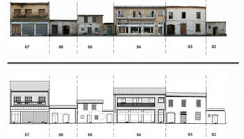
The scope of this project was the creation of such 2D drawings and rectified images of cultural buildings’ façades. Additionally, a survey of the general area of the buildings was also performed for the production of local survey maps. The project covered an area with approximately 488 different buildings.
In order to create the façade’s models we used both traditional surveying and single image Photogrammetry.For each building façade a number of control points and points of interest (balconies, architectural details, and roofs) were measured. For each façade we produced one or more rectified images, depending on the number of dominant planes in each façade. The rectified images were used to create facades’ drawings, which were complemented with the surveying measurements. Furthermore, the façades were geo-referenced, to produce detailed series facades of building along the street.
- Creation of 2D building facades drawings
- Large Amount of data
- Time constrained Project
- Flat Building Facades
- Sufficient Accuracy for the project
- Fast Processing Time
- Fast Data Collection