January2013
Documentation of the Historical rail way of Pilio
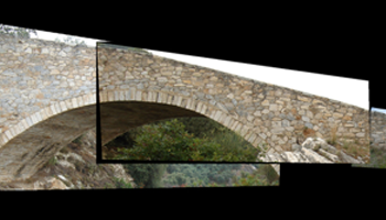
Identification of major technical works, bridges and network stations Photographic documentation and finding relevant information, historical and technical interest Impression and rendering of the Kouklakis arch-stone walkway at Ano Gatzea and the Taxiarchis Bridge Distribution, use and utilization of the Volos OSE technical service file
» » » »eMMCA – Virtual Macedonian Museum of Contemporary Art
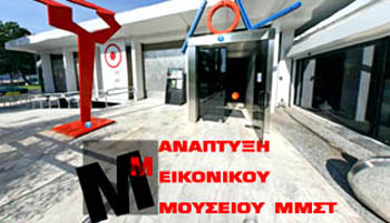
Title: Development of the virtual museum of MMCA (Museum of Contemporary Art, Thessaloniki, Greece) The virtual museum is accessible via the internet by providing a collection of digital objects that are logically connected to each other and reproduce traditional communication and inter-activity methods with the guests according to their needs[…]
» » » »Award ARISTEIA for the research program
The research project «Study, Analysis and Processing of worldview-2 satellite Imagery, for evaluating the energy efficiency of the urban area of Thessaloniki, Greece», the A. Stamou, who was part of the doctoral thesis supervisor Prof.Petros Patias excelled in international contest 8-Band Research Challenge. The work was awarded to the bidder Digital-Globe[…]
» » » »Egnatia Highway Project
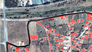
Τitle: A case study of land changes in EGNATIA highway Funding: EGNATIA ODOS A.E. Aim: The purpose of this study is to investigate at a pilot stage the land cover changes occurring in selected areas under direct influence of the ‘Egnatia’ highway. This is accomplished with the estimation of two[…]
» » » »EFFMIS
Title: A Geographical Information System for the management of forest data MED Funding Description: Land uses in forest districts and digital terrain model, according to forest species, meteo data, fire brigades navigation, forest management and water supplies. http://www.effmis.eu/
» » » »PROFORBIOMED

Title: PROFORBIOMED The PROFORBIOMED project is a strategic MED project under the transational European Territorial Cooperation programme, that meets the objective 2.2. : “Promoting renewable energy and improving energy efficiency.” The project is linked to the promotion of the use of renewable energies by the development of an integrated strategy for the use[…]
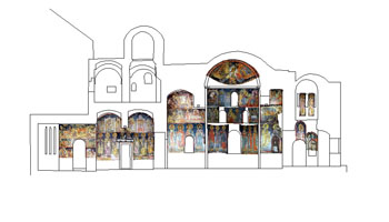
» » » »3D Mapping of the church of Panagia Kera, Crete
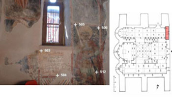
Title: 3D Mapping presentation of the church Panagia Kera in Kritsa, Agios Nikolaos, Crete Objective: The three-aisled vaulted domed church of Panagia Kera in Crete is dedicated to the Assumption. The temple was gradually built. Originally built in the nave of the church on the type of hall church with[…]
» » » »Digital Cities – Cyprus
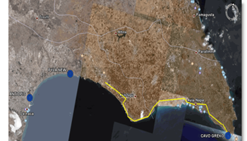
Title: Digital cities in Cyprus: the technology of network of permanent GPS data recording stations in the service of society Funding: Cyprus Research Promotion Foundation The program aims to provide specific research infrastructures in scientific and research community of Cyprus on the establishment and operation of permanent stations of the Global[…]
» » » »Famagusta – Othello Tower
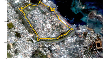
The project ”Photogrammetric Survey of the Othello Tower in the Medieval Walls of Famagusta, Cyprus”, funded by the European Union and implemented by the Partnership for the Future Programme, established by the United Nations Development Programme and executed by UNOPS. The project implemented by GeoImaging Ltd. The most appropriate methodology[…]
» » » »3D mapping of the Dionysiou Monastery, Mount Athos