November2013
Mobile Mapping system
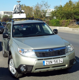
How it works A complete solution for data collection with the laser data acquisition method, the photogrammetric 3D and data processing with stereoscopic 3D GIS interface for fast data collection. The system uses the latest laser scanner technology, cameras, odometer, inertial and satellite navigation. It is a very quick and[…]
» » » »RC – Balloon System

Title: Unmanned aerial photography system, RC Balloon. Funding: Research Committee, AUTH. Objective: To establish the system inexpensive aerial photography, for measuring and thematic documentation urban and suburban space. The system consists of three (3) main parts: the balloon, the receiving system, and the ground station.
» » » »RC Helicopter System
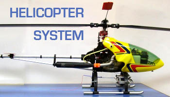
Title: Unmanned aerial photography system, RC Helicopter System. Funding: Scholarship of Heraclitus and School of Rural & Surveying Engineering, Aristotle University of Thessaloniki. Objective: To establish the system inexpensive aerial photography, for measuring and thematic documentation urban and suburban space. The unmanned helicopter model is the company VARIO and has capacity of[…]
» » » »3D Mapping of the Church of Protaton, Mount Athos

Title: Photogrammetric mapping murals Protaton karyes Funding: KEDAK Objective: The problem of photogrammetric surveying of the murals of Protaton Karyes Mount Athos was very complex and in large scale. The extent of the surface to fix it was more than 600 m2 and it took over 4000 of control points, which[…]
» » » »3D Mapping of the historical center of Nicosia, Cyprus
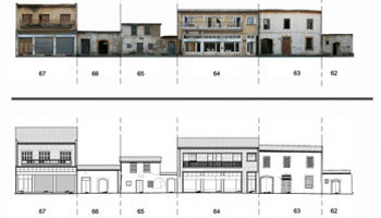
Title: Mapping of Buildings FACADES’ at the Historical Centre of Nicosia, Cyprus and creating a Preservation Information System Funding:Municipality of Nicosia, Cyprus Purpose: The scope of this project was the creation of such 2D drawings and rectified images of cultural buildings’ façades. Additionally, a survey of the general area of the buildings[…]
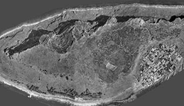
» » » »The Keros Research Project – Cycladic Early Bronze Age
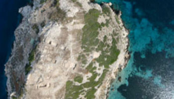
Title: The Keros Research Project, 2008. Investigating the international spirit of the Cycladic Early Bronze Age. Purpsose: Photogrammetric documentation and digital representation of excavations at Keros island in the Cyclade. An autonomous UAV (Unmanned aerial vehicle)-helicopter, equipped with a digital camera, was used for the photogrammetric documentation of the study[…]
» » » »Registry of the Cyprus Vineyards
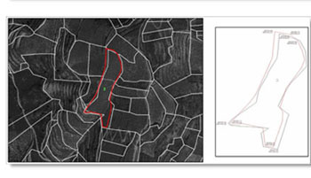
Title: Registry of the Cyprus Vineyards Funding: Cyprus Research Promotion Foundation Estimated harvest grapes using Remote Sensing and GIS. Research and data collection for creating data base plots, property and loss management program. New technologies as a promotion tool of the course of the vine and wine.
» » » »Monemvasia – GIS project application for Castles of Peloponissos
Title: Project for creation a GIS application for Castles of Peloponissos – Capturing the castle of Monemvasia This application is intended to create a Geographic Information System (GIS) that shows how and the methodology for creating thematic maps for information of scientists and the general public, providing information on the[…]
» » » »Coastal front of the Historical Centre of Thessaloniki
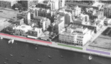
Title Temporal study of coastal front of the Historical Centre of Thessaloniki in Nothern Greece The study refers to the visual representation of the coastal front of the historical center of Thessaloniki in northern Greece and its changes that have occurred through the years. Most of the old town was[…]
» » » »3D Laser Scanner – Cyclops Polifemus Cave, Maroneia
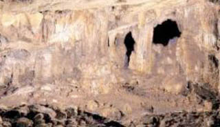
The choice of Cyclops Polifemus Cave was based on its historical significance as according to archaeologists there is evidence of its use since prehistoric times. The myth under stories is telling that Polyphemus’s blindness caused by Odysseus. Cyclops Cave is located in the prefecture of Rodopi at municipality of Maroneia.[…]
» » » »