Coastal front of the Historical Centre of Thessaloniki
Title Temporal study of coastal front of the Historical Centre of Thessaloniki in Nothern Greece
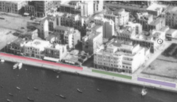
The study refers to the visual representation of the coastal front of the historical center of Thessaloniki in northern Greece and its changes that have occurred through the years. Most of the old town was destroyed by fire on August 18 1917. A few years later, the French architect and archeologist Ernest Hébrard proposed the reconstruction of the city centre, but his plans were never fully implemented. Since then, a series of interventions changed the form of the old town and consequently the coastal cityscape.
The research was initially based on the photogrammetric processing of archive aerial images (1938) of Thessaloniki’s city centre. Besides the vertical images, high oblique aerial images dated back to 1932, proved to be a significant source of information. A rich archive of old photographic material, sketches, drawings and gravures of the coastal forehead of the city was also used. Ortho-images of the coastal front, derived from laser scanning (2010), and a 3D model of the historical city centre, derived from the stereo photogrammetric process of aerial images (1990), contributed decisively at the multi temporal study of the city front.