Environment
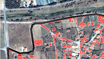
Registry of the Cyprus Vineyards
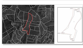
Title: Registry of the Cyprus Vineyards Funding: Cyprus Research Promotion Foundation Estimated harvest grapes using Remote Sensing and GIS. Research and data collection for creating data base plots, property and loss management program. New technologies as a promotion tool of the course of the vine and wine.
» » » »Monemvasia – GIS project application for Castles of Peloponissos
Title: Project for creation a GIS application for Castles of Peloponissos – Capturing the castle of Monemvasia This application is intended to create a Geographic Information System (GIS) that shows how and the methodology for creating thematic maps for information of scientists and the general public, providing information on the[…]
» » » »Coastal front of the Historical Centre of Thessaloniki
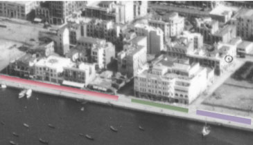
Title Temporal study of coastal front of the Historical Centre of Thessaloniki in Nothern Greece The study refers to the visual representation of the coastal front of the historical center of Thessaloniki in northern Greece and its changes that have occurred through the years. Most of the old town was[…]
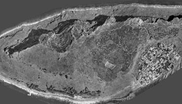
» » » »Case study of of the dam of Pramoritsa
Title: Study of the protection, management and development of the naturel and residential environment of the dam of Pramoritsa Funding: Perfecture of Kozani Aim: Create a network of control points using GPS and production photogrammetry background, ie the Digital Terrain Model (DTM), and the orthophoto (land use and road, vegetation-land[…]
» » » »Earthquake 1978 Thessaloniki and Fire

Project for Earthquake 1978 – Fire of Thessaloniki Study area of Historical center of Thessaloniki. Photogrammetric methods were attributed to the roofs and terraces of buildings to create three-dimensional solid buildings.
» » » »Ski Resort – Seli

Recording and Mapping of Ski Resort
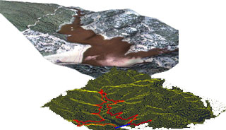
» » » »Tempe Valley – Risk management – 3D Photogrammetric Mapping

Title: Three-dimensional photogrammetric mapping eastern slope valley Tempe Funding: Egnatia Odos SA Objective: The depiction of terrain model of the region of the rocks of Tempe, which formed the basis for investigating the causes of accidents. Imprinting the slope in approximately 4 km, with an accuracy of better than 50[…]
» » » »Award ARISTEIA for the research program

The research project «Study, Analysis and Processing of worldview-2 satellite Imagery, for evaluating the energy efficiency of the urban area of Thessaloniki, Greece», the A. Stamou, who was part of the doctoral thesis supervisor Prof.Petros Patias excelled in international contest 8-Band Research Challenge. The work was awarded to the bidder Digital-Globe[…]
» » » »Egnatia Highway Project
Τitle: A case study of land changes in EGNATIA highway Funding: EGNATIA ODOS A.E. Aim: The purpose of this study is to investigate at a pilot stage the land cover changes occurring in selected areas under direct influence of the ‘Egnatia’ highway. This is accomplished with the estimation of two[…]
» » » »EFFMIS
Title: A Geographical Information System for the management of forest data MED Funding Description: Land uses in forest districts and digital terrain model, according to forest species, meteo data, fire brigades navigation, forest management and water supplies. http://www.effmis.eu/
» » » »