November2013
RC – Balloon System
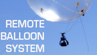
Title: Unmanned aerial photography system, RC Balloon. Funding: Research Committee, AUTH. Objective: To establish the system inexpensive aerial photography, for measuring and thematic documentation urban and suburban space. The system consists of three (3) main parts: the balloon, the receiving system, and the ground station.
» » » »RC Helicopter System
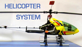
Title: Unmanned aerial photography system, RC Helicopter System. Funding: Scholarship of Heraclitus and School of Rural & Surveying Engineering, Aristotle University of Thessaloniki. Objective: To establish the system inexpensive aerial photography, for measuring and thematic documentation urban and suburban space. The unmanned helicopter model is the company VARIO and has capacity of[…]
» » » »3D Mapping of the Church of Protaton, Mount Athos

Title: Photogrammetric mapping murals Protaton karyes Funding: KEDAK Objective: The problem of photogrammetric surveying of the murals of Protaton Karyes Mount Athos was very complex and in large scale. The extent of the surface to fix it was more than 600 m2 and it took over 4000 of control points, which[…]
» » » »3D Mapping of the historical center of Nicosia, Cyprus
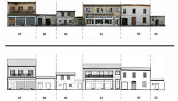
Title: Mapping of Buildings FACADES’ at the Historical Centre of Nicosia, Cyprus and creating a Preservation Information System Funding:Municipality of Nicosia, Cyprus Purpose: The scope of this project was the creation of such 2D drawings and rectified images of cultural buildings’ façades. Additionally, a survey of the general area of the buildings[…]
» » » »